Navitel Navigator. Kyrgyzstan


Availability: 42
The goods are in stock seller!

Digital content
Link + License key
Seller information


Questions
Description Navitel Navigator. Kyrgyzstan
Developer: Navitalai: Russian
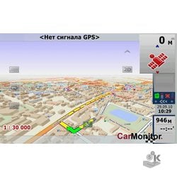
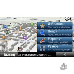
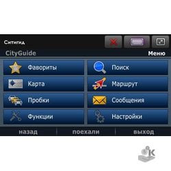
Navitel. Navigation system with map package (Kyrgyzstan) – a unique and accurate navigation system, including detailed map of Kyrgyzstan and free services Navitel.Traffic, Navitel.SMS, Navitel.Events, Dynamic POI, Navitel.Friends and Navitel.Weather.
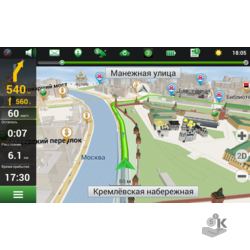
- Navitel. Tube Free service. All users Navitel Navigator are active participants in the definition of congestion and free roads. When the service Stoppers, data on the speed of movement of the vehicle are collected and sent to an analytical center, where these data are processed and made available to users in the form marked on the map tubes*. *Tube.Navitel only displayed on the maps produced by JSC CNT.
- Search – everything Search maps is based on the principle are ALL subject to various specific addressing (housing, buildings, ownership, dual addressing, etc.). Knowing the exact address, users Navitel Navigator can easily find it on the map, and predictive search system (principle T9) allow even faster and more convenient to type the name of streets and cities on the telephone keypad.
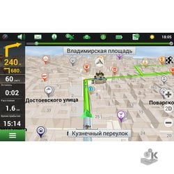
- Routes One of the main functions of the navigation system is the routing of traffic through the city and out of town. The program Navitel Navigator implements a flexible algorithm for constructing routes, allowing the user to build routes based on their own preferences.
- SPEEDCAM is No secret that the most dangerous sections of road are increasingly installed speed control (SPEEDCAM). In order to warn the driver of approaching a dangerous area, we have developed a system of early alerts. With this technology, the driver will receive advance information of approaching a dangerous area and will be able to reduce the speed. Point database SPEEDCAM constantly updated and supplemented. Over her work as a professional cartographers, and the users themselves. Information on hazardous areas (crossings, radars, speed bumps)
- Navitel.SMS Free service. This service allows you to send SMS with coordinates of your location. The SMS recipient can view the place on the map with the coordinates passed to the SMS, and directions to it.
- Navitel.Events a New free interactive service allows users to mark and see the map navigation device mark other users about various events of the following types: accident, accidents, road works, the camera tracking speed and other warnings.
- Dynamic POI using the service of dynamic POI You can find prices for gasoline at the pump, showtimes at cinemas, detailed information about restaurants and cafes, indicating deals and phones for booking tables and much more.
- Navitel.Weather Service Navitel.Weather allows you to view the weather forecast anywhere in the World, weather information is available three days in advance.
- Navitel.Friends Interactive service Navitel.Friends allows you to monitor the location of your friends on a map in real time, exchange messages or make a route to meet them.
- Nearest objects in a given radius
- Settlements and objects within settlements (type and name)
- At
- Points of interest (POI)
- Waypoint
- At last found objects
- At the crossroads
- Voice guidance is automatically created route
- The speed and direction of movement
- The coordinates (latitude and longitude, altitude above sea level)
- Automatic time zone selection
- The traversed path length, movement time and speed
- Record tracks and waypoints
- Export/import tracks
- Export/import routes
- The direction of movement to a given point with the prediction of the arrival time
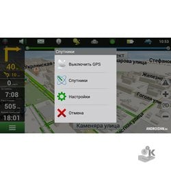
- Information about GLONASS/GPS satellites
- The ability to manage the program without the stylus (for drivers of large buttons under the finger on the touch screen)
- Voice prompts
- The choice of voices from several voice packets and connect their own voice package
- Russian interface
- More than 100 different sensors (trip computer)
- Automatic detection exchange Protocol and COM-port when connecting to GLONASS/GPS-receiver
- The ability to automatically enable/disable BlueTooth when connecting to GLONASS/GPS
- The choice of skin files
Tags: Navitel Navigator. Kyrgyzstan,Android,Different programs
Specification Navitel Navigator. Kyrgyzstan
| Technical | |
|---|---|
| Operating system | Программу Навител. Навигатор можно использовать:на всех смартфонах, планшетах под управлением ОС: Android, BlackBerry Q10/Z10/Z30, Windows Phone 8/8.1/10 mobile, Tizenавтонавигаторах, если по умолчанию в них установлена программа Навител. Навигатор (для покупки или аренды карт)Программу Навител. Навигатор нельзя использовать:во всех автонавигаторах, в которых программа Навител. Навигатор не была изначально установлена по умолчанию (при продаже)Необходимая оперативная память при запуске не менее 40 МбРазмер свободного места, необходимый для установки программы, зависит от технических характеристик устройстваМинимальное разрешение дисплея 320х240 |
| Product Details | |
| SKU | NAV-27 |
Related Products


 Домашняя версия")